

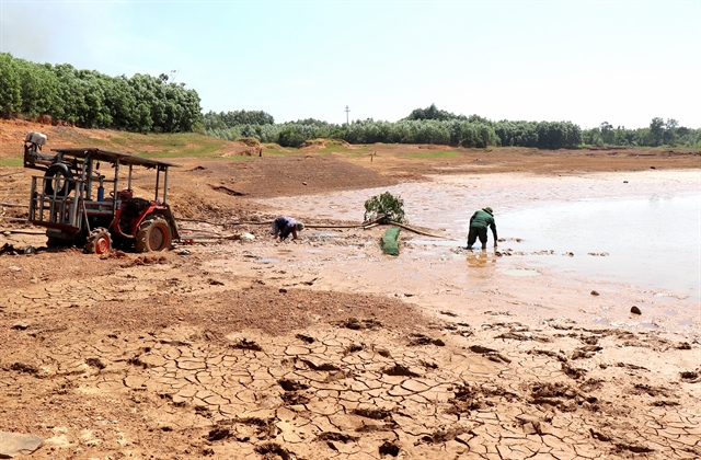
In late January 2016, in the middle of what was shaping up to be one of the mildest winters northern Việt Nam had seen in years, something strange happened.
Over five days, temperatures collapsed. Frost coated hillsides across the northern mountains and in a few places it snowed, a sight rare enough that people drove for hours just to see it.
Meteorologists later called it one of the harshest cold snaps the region had endured in more than four decades. It struck, improbably, during a strong El Niño – the very pattern that was supposed to be keeping that winter mild.
That episode has become a cautionary tale for forecasters, and it’s back in circulation now, a decade later, as a new El Niño builds toward what could be one of the strongest on record.
The broad trend it points to is hotter, drier weather and a quieter storm season. But 2016 taught meteorologists that averages can mislead and, this time, getting caught out by the exception could be far more costly.
“El Niño is currently at strong intensity,” said Mai Văn Khiêm, director of the National Centre for Hydro-Meteorological Forecasting, noting that sea-surface temperatures in the benchmark NINO3.4 region were running 1.8 degrees Celsius above the long-term average in early September.
His centre believes the pattern will almost certainly remain at strong-to-very-strong intensity through the final quarter of 2026, with a 98 per cent probability of reaching “very strong”, before easing gradually, while remaining detectable well into the first half of 2027.
For most of the country, that points to a milder version of the season: cold snaps arriving later and less often, national temperatures running 1 to 2.5 degrees Celsius above average and roughly 28 per cent fewer storms than usual.
Rainfall is expected to fall 20 to 40 per cent short across the South Central Coast, the Central Highlands and the South during what should be the height of this year’s rainy season, which now looks likely to end early. Then, come early 2027, heat is expected to arrive ahead of schedule and hit hard. There may be more scorching days than in 2026 and possibly some readings beyond anything on record. None of which rules out a repeat of January 2016.
“Even though El Niño typically brings higher temperatures, less rain and fewer storms and cold spells, that doesn’t mean extreme weather won’t happen. Anomalous events, ones that break the usual seasonal pattern, can still occur, even with real intensity,” Khiêm said.
If there’s one theme running through Việt Nam’s preparations, though, it isn’t storms. It’s water.
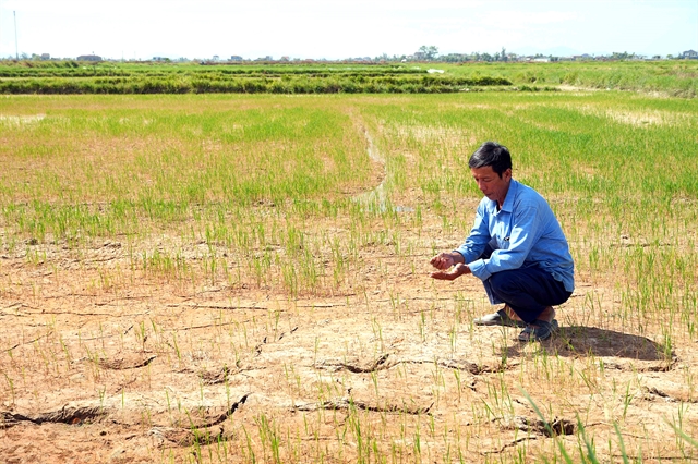
“The impact worth worrying about most right now is the rising risk of water shortages, drought and, along the coast, saltwater intrusion,” Khiêm said, though the danger won’t fall evenly; it depends on the region, the timing and what’s being grown there.

Nasty combination
The Central Highlands is a particular concern, with scarcity expected to build from late this year and peak in early 2027, threatening not just rice but coffee, pepper and fruit orchards. For rice, timing is everything: a shortage during sowing or the yield-determining panicle stage does far more damage than one arriving later.
The Mekong Delta faces a nastier combination of drought and saltwater intrusion. As freshwater flow drops, a strong tidal surge meeting a weak river current pushes saltwater further inland, squeezing farms near river mouths.
For orchards, the danger is drawing on water that’s turned brackish, which can damage root systems outright.
The Mekong’s flow into Việt Nam is expected to run below average through the rest of 2026, with a deficit of roughly 30 per cent between January and May 2027. From February through April, tidal surges could push salinity levels of 4 grams per litre tens of kilometres inland, threatening the winter-spring rice harvest, the following summer-autumn sowing, orchards, aquaculture and drinking water.
It’s why forecasters describe a shift in their own methodology: from forecasting El Niño to forecasting its impacts region by region – answering where the risk is, when it will hit, who it affects and what needs to be done beforehand, so the data become something officials can actually act on.
The scale of what’s at stake is starkest in the numbers from the Water Resources Management Department. Between June and August, flows across 12 of the country’s major river basins ran between 10 and 75 per cent below average.
The lesson from past droughts is that trouble tends to begin at the end of the flood season, when reservoirs fail to fill. That happened previously, when 43 major hydropower reservoirs came up short by a combined 7.7-11 billion cubic metres.
Exposure varies sharply by region. In the Central Highlands, 735,300 hectares of coffee, pepper and other perennial crops sit outside any irrigation network, with only 17-19 per cent of the region considered water-secure.
In the southeast, the Đồng Nai River basin – under more dry-season stress than any other in the country – supplies 91 per cent of urban water from upstream reservoirs alone, putting some 26 million people at risk if flows fall and salt water pushes inland.
And in the Mekong Delta, despite having the country’s largest volume of water, 87.3 per cent of urban supply is drawn straight from rivers with no regulating infrastructure behind it, leaving the region acutely exposed if flows drop 40-60 per cent and salt water pushes up to 70 kilometres inland.
Acting now
Local governments are already responding. In Cà Mau, a survey found nearly 13,800 households at risk of losing access to water, prompting urgent repairs to rural infrastructure and the provision of emergency storage tanks, the province’s Vice Chairman Lê Văn Sử said on September 8.
Nationally, Châu Trần Vĩnh, director of the Water Resources Management Department, frames the strategy simply: regulate and distribute water early and stay well ahead of the problem, rather than scramble once it arrives.
Starting this month, localities should be filling reservoirs while managing flood control, adjusting planting seasons, switching crops where water can’t be guaranteed and restoring backup boreholes, with drinking water treated as the non-negotiable priority throughout.
Detailed water availability forecasts for the Red River and the Mekong are due out in October, with the rest of the country’s basins following in November and December.
Storms remain the wildcard. Forecasters expect below-average activity in the East Sea through December. Typically, the region sees 4.5 storms a year, with 1.9 making landfall.
But a quieter season isn’t necessarily a safer one. Climate expert Nguyễn Ngọc Huy expects fewer floods and storms overall than in 2025, but cautions that a super El Niño year is exactly the kind that can still produce one outsized typhoon.
“It’s a pattern that keeps reasserting itself: the averages point one way, but it’s the exceptions – a frost in a warm winter, one ferocious storm in an otherwise quiet season – that tend to do the real damage,” Huy said.
Huy’s advice, for now, is narrower but no less urgent: the Central Highlands and the Mekong Delta should be filling their reservoirs, canals, jars and tanks now, rather than waiting for the rains to wind down. By the time they taper off, he warned, there wouldn’t be enough left falling to fill the regions’ backup reserves before the 2027 dry season arrives.
(VNS)